La Carélie russe en hiver avec nos pumis... Part 1 : la préparation du voyage
Par Joel pumi le lundi, février 9 2015, 16:20 - Lien permanent

, fév. 2015")
Introduction
La République Autonome de Carélie est située au nord-ouest de la Fédération de Russie, entre les bassins de la Mer Blanche et celui de la Mer Baltique.
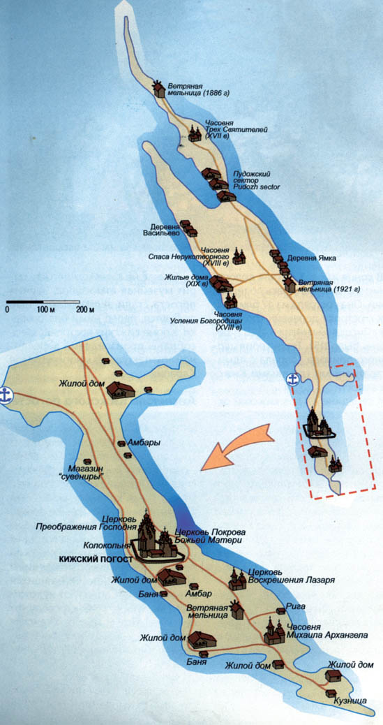
Elle est frontalière avec la Laponie (Une longue frontière la sépare de la Finlande à l'ouest sur 723 km). Son vaste territoire se compose presque intégralement de forêts. Ce que le vert n'a pas recouvert est dominé par le bleu. En effet, la Carélie où coulent 27 000 rivières compte 60 000 lacs. Parmi eux deux des plus grands lacs européens : le Ladoga et l'Onéga. La nature règne donc en maitre en Carélie. Les hommes sont ici moins nombreux que les ours, les lynx et les loups. Hormis Petrozavodsk (Петрозаводск), la capitale, ces premiers habitent des villages égayés de maisons et d'églises aux couleurs vives. On ne peut évoquer la Carélie sans parler d'un de ses trésors : Kiji (Kizhi). Cette ile, située sur le lac Onéga est célèbre pour ses chefs-d'œuvre d'architecture en bois. Le plus impressionnant est l'église de la Transfiguration du Sauveur et ses 22 bulbes.
Une région de lacs et de forêts
Il y a 60 000 lacs en Carélie dont les deux plus grands d'Europe : Le Lac Ladoga et le Lac Onega. Des lacs parsemés d’iles, la plus connue du Lac Onega étant l’ile de Kiji, célèbre pour son patrimoine architectural (constructions en bois) classé au patrimoine mondial de l'Unesco.
Environ 70% du territoire est couverts de forêts : conifères (sapins, pins) et bouleaux . Petrozavodsk (la capitale de la Carélie) est située à 425km de Saint-Pétersbourg.
- site non officiel de Petrozavodsk http://www.ptz.ru/
- site officiel http://www.petrozavodsk-mo.ru/
- site culturel http://kultura.ptz.ru/
- Kizhi museum http://kizhi.karelia.ru/info/en/abo...

La Carélie, une histoire riche...
On retrouve la présence dans la région de chasseurs et de pêcheurs russes venant de Novgorod dès le XIIéme siècle, ensuite la région est occupée par les Suédois puis annexée par la Russie en 1323. Pierre le Grand en 1721 installe ses fonderies d'armement à Petrozavodsk. Pendant la période de la Révolution russe de 1917, la région est déchirée par des combats entre les troupes finlandaises et russes. En 1920, un traité partage la Carélie entre une partie attribuée à la Finlande et l'autre, la Carélie orientale, à la Russie. Mais en 1940 les troupes soviétiques envahissent une partie de la Carélie finlandaise. En 1956, la Carélie bénéficie d'un statut de République autonome et le 13 novembre 1991, elle proclame sa souveraineté au sein de la Fédération de Russie.En résumé : Russe, suédoise, finnoise ... et désormais russe !
Les Caréliens
716 000 habitants (en 2002) vivent dans cette vaste région nordique, la densité est faible moins de 4 hbts au km2. La capitale régionale est la ville de Petrozavodsk (268 724 hbts en 2008), elle est située au bord du Lac Onega. Une population essentiellement russe à 68%, le Russe étant la langue officielle. La langue carélienne étant parlée par environ 10% de la population.
Les ressources économiques ?
Principalement, l'exploitation forestière avec l'industrie du traitement du bois (papier, meubles). Présence également de mines (zinc, mica, fer ...) et d'industries métallurgiques. Le tourisme aussi, surtout en été avec les croisières sur les les fleuves et les lacs et vers l’ile de Kiji. L'agriculture (pommes de terre, céréales surtout dans le sud de la région) est peu développée, le climat local n'y est pas vraiment favorable.
Le climat carélien ?
Des hivers froids adoucis par les masses d'air humide venant de l'Ouest d'où un enneigement abondant et un ciel souvent couvert. Février est le mois le plus froid avec des températures moyennes oscillants entre -10°C et -14°C (c'est pour cela que nous avons choisi ce moment pour nous y rendre!), les lacs et les fleuves sont gelés environ 5 mois par an. L'été est plus clément même si les températures n'avoisinent en moyenne que les 14 à 16°C en raison de la latitude nordique de la région.
Des sites web à consulter :
- Plein, plein d'infos (en anglais, finlandais et russe) http://heninen.net/english.htm
- Site officiel de la République de Carélie http://www.gov.karelia.ru/
- Sites touristiques de la Carélie http://www.gov.karelia.ru/gov/Info/...
- Portail touristique de la Carélie http://www.ticrk.ru/en/
- Cartes http://www.infokart.ru/?s=%D0%9F%D0..., http://www.infokart.ru/karta-rajono...
- http://tourism.karelia.ru/
- Le centre des médias finno-ougrienne est l'une des principales ressources web sur les questions finno-ougriennes http://finugor.ru/
- un blog plein d’intérêts : http://www.langue-russe.asso.fr/Voy...
- Plein de choses sur la culture finno-ougrienne en Carélie russe http://fusee.tv/#id=389&heading...
- http://explorussia.com/blog-karelia...
- http://explorussia.com/item/active-... tour touristique
- http://www.ticrk.ru/en/
- http://www.russieautrement.com/excu...
- Un blog russe avec plein de photos hivernales de l'ile de Kizhi http://jane-sea.livejournal.com/106...
 et la voiture pour aller sur l'ile en hiver : http://www.karelavto.ru/news/karel/... (si l'on ne veut pas prendre l'hélicoptère, l’hydroglisseur ou une motoneige!
  )
)
Les beaux sites touristiques de Carélie :http://www.russie-voyage.com/voyage...
- Sortavala et les iles de Valaam (Le monastère, les sculptures naturelles) http://www.sortavala.ru/w_valaam/Du... http://www.sortavala.ru/
- Musée de Kizhi
- Chutes de Kivatch sur la rivière Suna
- Église Assomption Kondopoga
- Zones protégées de Carélie
, fév. 2015")
- Forêts et sanctuaires naturels de Carélie
- Réserve de Kivatch
- Réserve Kostomoukcha
- Parcs naturels de Carélie
- Parc national de « Paanajärvi »
- Parc naturel de l’Archipel Valaamsky
- Parc national de Vodlosersky
- Parc national de Kalevalsky
- Lacs et rivières de la République de Carélie
- Le lac Ladoga
- Le Lac Onego
- Le festival de Kindasovo
- La terre antique des Caréliens de Syamozero http://syamozero.ru/index.php?title... https://www.youtube.com/watch?v=S-a...
- Les sites et les monuments du district de Pudozhsky
- Le bouleau de la République de Carélie
- Les pétroglyphes sur la rive orientale du lac Onego (Peri Nos, Besov Nos, Kladovets et Karetsky Nos)
- Les pétroglyphes de la mer Blanche
- Cathédrale de la ville de Kem
- Kusovy, iles de la mer Blanche


In english
Republic of Karelia
The Karelia Republic is located to the north of St. Petersburg and borders Murmansk Region in the north, Leningrad and Vologda regions in the south, Arkhangelsk region in the east and Finland in the west. Karelia covers 180,500 sq. km, which is 1% of the Russia’s total territory. Karelia is divided into 19 municipal districts.
The population of Karelia is 693 681 (2012) and the density of the population is 3.8 people per 1 sq. km. The average age of the population is 36.5 years. The capital is Petrozavodsk (population 282 000). Other “large” cities in the republic are Kostomuksha (32 500), Sortavala (20 200), Kondopoga, Segezha and Pitkäranta.
Nationalities in Karelia are: Russians 73.6%, Karelians 10%, Byelorussians 7%, Ukrainians 3.6%, Finns 2.3%, Vepps 0.8%. 37% of the population lives in the capital of the Republic Petrozavodsk.
Climate
The cold winter climate is modified by warm, humid air masses from the west, but incursions of Arctic air cause severe cold spells. During February, the coldest month, temperatures average 10 °C in the south and 14 °C in the north. Summers are short, cool, and susceptible to frosts, with average temperatures of 16 °C in the south and 14 °C in the north. Annual precipitation, mostly in the form of snow, varies from 400 mm in the north to 600 mm in the south, with snow cover in the Ladoga region accumulating to 1,000 mm. Average temperature in January 2005: 5.1 ° C and in July 2005: +17.0 ° C
Natural Resources
The largest part of the territory of Karelia is a hilly plain with evident traces of glacier. The wavy surface of the land keeps the traces of ancient mountains. More than 49% of the republic area is covered with forest (main species are pine and fur tree), 25% of the territory is watery surface. There are more than 60 thousand lakes and 27 thousand rivers in Karelia. The largest are the Ladoga lake (area is 17,7 thousand square km) and the Onega lake (area is 9,9 thousand square km). The largest rivers are: Vodla (400 km), Vyg, Kovda, Kem, Suna, Shuya. The total length of the rivers is about 83 thousand km.
More than 50 types of minerals, located in more than 400 deposits were discovered in Karelia. The minerals are: iron ore, vanadium, molibden, rare metals, diamonds, mica, construction materials (granite, marble, diabasis), clay, appatit-carbonate ore, asbest.
Economics
The Republic of Karelia has favorable economic-geographic location, it is situated near central highly industrially developed Russian and Western regions, has a developed water transportation system, and significant natural resources.
Mining, metallurgy, and timber working and processing are the major industries. Others include power engineering, machine building, and food processing. Iron ore, copper, mica, titanium, and pegmatite are the chief minerals mined.
Timber cutting and processing is the largest industry, producing saw timber, pit props, railway ties, paper and pulp, furniture, veneer, and prefabricated materials. Agricultural land occupies less than 3 percent of the total area, with much of this used for pasture to support dairy cattle and other livestock or to breed mink and blue polar foxes for fur. Fishing is important on lakes, rivers, and along the White Sea coast.
Karelia’s invaluable asset is its unspoiled environment, lakes and forests, as well as some outstanding monuments of architecture and history. According to Karelia officials, gross income from tourism was 1,25 billion rubles (approximately $40 million) in 2001.
Transport Infrastructure in the Republic of Karelia
The Republic of Karelia can be regarded as the transportation link between northwestern and central Russia, and the countries of Northern Europe. Karelia’s role as an important transportation junction is expected to grow even more after the completion of the Ledmozero Kochkoma railroad and the Petrozavosk Parikkala motorway, both of which are under construction. The pipeline from Shtockmanovskoye gas field could also be led through the Karelian territory.
- Road : There is one Federal road in the Republic of Karelia, the 780 km long stretch of the St.Petersburg Murmansk motorway which is paved with asphalt. The main overland transportation axis in Karelia runs north-south along the eastern edge of the Republic, as a part of the national rail and road link between St.Petersburg and Murmansk.
- Railway : A major railway from St. Petersburg to Murmansk crosses Karelia from south to north, with branches to all major towns. The railway is a link connecting the Urals with Finland and other Nordic countries. Carrying capacity of the new railway is 28 million tons annually. This railway aims to provide a short transportation route from Karelia to Finnish ports in the Gulf of Bothnia. The M18 national highway runs parallel to the railway and fairly close to it, both of them running via Petrozavodsk.
- Air Connections : The main airport of Petrozavodsk, Besovets, is the destination of all international and federal flights to and from the Republic of Karelia. There were international links to Helsinki via Joensuu, as well as to Tallinn and Riga. Within the Republic of Karelia, seven airports has regular connections to Petrozavodsk. They included Sortavala, Kostomuksha, Kalevala and Pudozh.
- Waterways : The Republic of Karelia also has two major waterways, one is the 227 km long White Sea Canal, which links Belomorsk on the White Sea with Poventsa at the northern tip of Lake Onega. For most of its length, it runs very close to the Murmansk road and railway axis, and gives access to most of the Karelian industrial centres. Another major waterway is the Volga Canal which is connected to the southern part of Lake Onega. It continues further to St.Petersburg and the Baltic Sea, passing along Lake Onega, down the River Svir, Lake Ladoga, and the Neva river.
Culture and education
Karelia is sometimes called "the songlands" in the Finnish culture, as Karelian poems constitute most of the Finnish national epic Kalevala.
The main tourist attractions in Karelia are Valaam, Solovki and Kizhi islands, Martsialnie Vody spa, largest in Europe plain waterfall Kivatch, national parks and protected natural territories. Kizhi islands alone hosted 120,000 tourists in 2001, half of which came from abroad.
Petrozavodsk State University is the largest educational institution in the European North of Russia and includes the following faculties: Faculty of History, Faculty of Forest Engineering, Faculty of Mathematics, Faculty of Medicine, Faculty of Baltic and Finnish Philology and Culture, Faculty of Industrial and Civil Engineering, Faculty of Agriculture, Faculty of Physical Engineering, Faculty of Philology, Faculty of Ecology and Biology, Faculty of Economics, Faculty of Law, Faculty of Political and Social Sciences. It also includes branches: Kola branch (Apatity, Murmansk region), Priladozhsky branch (Sortavala), Byelomorsk branch (Byelomorsk) and Kostomuksha branch (Kostomuksha), Educational centers in Segezha and Kondopoga. At present in the university there work more than 3600 teachers, faculty and staff members, there study over 19500 undergraduate and graduate students, every year more than 4100 students take training, re-training and professional development.
Karelian Research Centre of the Russian Academy of Sciences is also located in Petrozavodsk.
For more information please go to :
- Official site of the Republic of Karelia http://www.gov.karelia.ru/
- Tourist Sights of Karelia http://www.gov.karelia.ru/gov/Info/...
- Karelia tourist portal http://www.ticrk.ru/en/
- The Finno-Ugric media center is one of the leading web resources on Finno-Ugric issues http://finugor.ru/
and also, to read :
- Genocide in Soviet Karelia: Stalin's Terror and the Finns of Soviet Karelia http://www.genealogia.fi/emi/art/ar...

Sources of information :
- Encyclopedia Britannica
- Wikipedia http://fr.wikipedia.org/wiki/R%C3%A...
- Kommersant – Russia’s Daily Online